In our series “Maps and mappers of the 2016 calendar” we will present throughout 2016 the mapmakers who submitted their creations for inclusion in the 2016 GeoHipster calendar.
***
Stephen Smith
Q: Tell us about yourself.
A: I’m a cartographer by night and a GIS Project Supervisor by day. I work for the Vermont Agency of Transportation where I help our rail section use GIS to manage state-owned rail assets and property. Most of the time my work entails empowering users to more easily access and use their GIS data. I’ve used Esri tools on a daily basis since 2008, but recently I’ve been playing with new tools whenever I get the chance. I attended SOTMUS 2014 in DC (my first non-Esri conference) and was really excited about everything happening around the open source geo community. I got some help installing “Tilemill 2” from GitHub and I haven’t looked back. Since then the majority of the maps I’ve made have been using open source tools and data. Lately I’ve been heavily involved in The Spatial Community, a Slack community of 800+ GIS professionals who collaborate to solve each other’s problems and share GIFs. I’m also starting a “mastermind” for GIS professionals who want to work together and help one another take their careers to the next level.
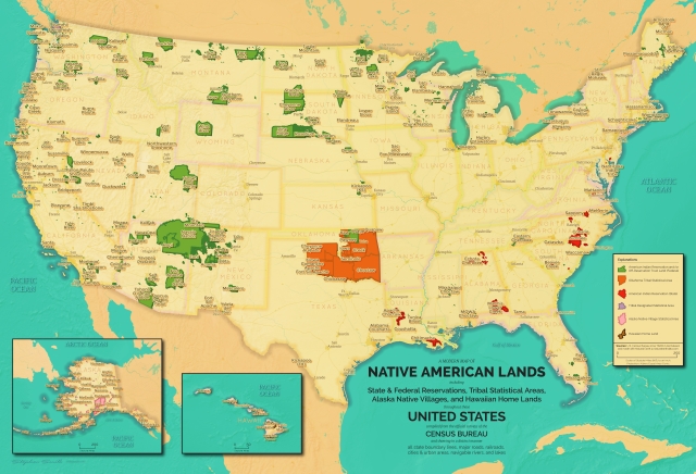
Q: Tell us the story behind your map (what inspired you to make it, what did you learn while making it, or any other aspects of the map or its creation you would like people to know).
A: This map was a gift for my cousin who is part Native American and works in DC as an attorney for the National Indian Gaming Commission. His wife told me that he really liked my Natural Resources map and she wanted me to make him something similar to the US Census American Indian maps but in a “retro” style. I took the opportunity to explore the cartographic capabilities of QGIS and was very impressed.
Q: Tell us about the tools, data, etc., you used to make the map.
A: I’ve done a full writeup of the creation of the map including the data, style inspirations, fonts, challenges, and specific QGIS settings used on my website. You can also download a high resolution version perfect for a desktop wallpaper.