In our series “Maps and mappers of the 2016 calendar” we will present throughout 2016 the mapmakers who submitted their creations for inclusion in the 2016 GeoHipster calendar.
***
Nathan Saylor
Q: Tell us about yourself.
A: I’m the GIS coordinator for Hardin County, Ohio, where I do a variety of map projects to support and promote various county entities. I really enjoy my position there as I’m a one-person shop and there is ample opportunity to learn and experiment with my craft.
I am also the owner of Saylor Mapping. This was started to answer the many requests coming to the county GIS for cemetery mapping services that the county felt was beyond its reasonable scope to handle. Saylor Mapping is also breaking into municipal utilities as well.
I am also very involved with #GISTribe, which has a scheduled meet every Wednesday at 3pm ET on Twitter (though we’re active all the time), as well as the gistri.be archive and blog.
Personally, my wife Marti and I have been married for nearly 18 years and have six clever kids.
Q: Tell us the story behind your map (what inspired you to make it, what did you learn while making it, or any other aspects of the map or its creation you would like people to know).
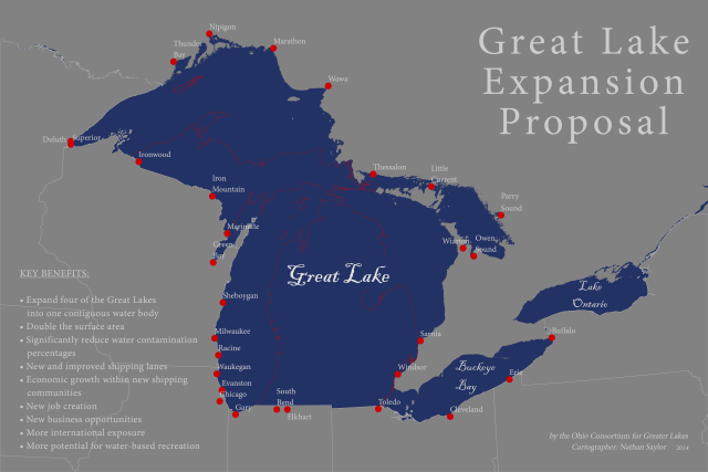
A: The deadline for the Ohio GIS Conference map competition was looming, so being in Buckeye country, I pondered what the map might look like if Michigan wasn’t there. I had never really thought about it, but looking at it, I considered what the impact of its sudden absence might be and within about 30 minutes came up with some economic reasons why this might be proposed by the fictitious Ohio Consortium for Greater Lakes.
Of course this is born out of the well-known rivalry between Ohio State and Michigan, and this was totally a play at the judges. While I had a lot of humored responses and requests for copies (download available here), sadly Ohio missed the opportunity to formally recognize the genius in their midst (I say with tongue firmly in cheek).
Q: Tell us about the tools, data, etc., you used to make the map.
A: The data was from Natural Earth, and I used ArcGIS Desktop. If you fancy yourself a fontophile and an anglophile, you’ll have noticed the font used for the lakes is Blackadder which was named for a British comedy alluding to the jest in which this map was made.
Go Bucks!