
Tell Us About Yourself
I graduated in 1996 from the Cartography: Digital Mapping program at the College (now Centre) of Geographic Sciences in Lawrencetown, Nova Scotia, Canada. At the time it was one of the few programs dedicated to cartography in North America, and to my good fortune I grew up nearby — I found out that I could make maps for a living by talking to COGS students at a career fair in my final year of high school.
After graduating I moved to Calgary to work as an independent consultant creating maps for biologists, ecologists, and geologists. Since relocating to South America in 2004, my work has focused on aerial surveying, environmental protection, transportation, and more recently, board games — yes, board games!
Tell us the story behind your map (what inspired you to make it, what did you learn while making it, or any other aspects of the map or its creation you would like people to know)
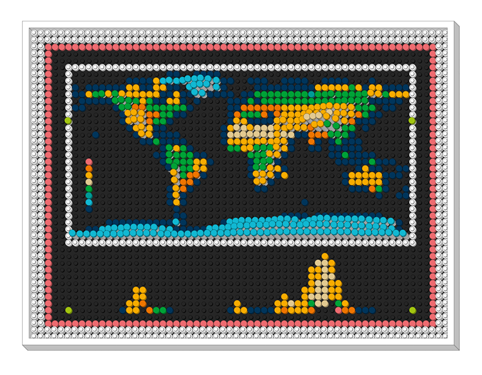
I made rudimentary maps out of LEGO bricks when I was young, so I was excited to find out that they would be releasing a World Map set. I wasn’t, however, very excited about their template, so I thought it would be a fun exercise to adapt the set to ESRI’s free global land cover data — it employs remarkably similar colours — and use the leftover pieces to portray realistic relief.
But before shelling out for this expensive 11,695-piece set, I needed to accurately simulate what my idea would look like, and the standard virtual “LEGO block style” map that simply portrays relief with drop shadows was not going to cut it. So I thought this would be a good opportunity to put both my cartographic and GIS skills to the test!
Tell is about the Tools, data, etc., that you used to make the map
The map’s 1×1 brick size (7.2°) was determined by the availability of each colour in the LEGO set, its frequency in the ESRI land cover data, and the desired aspect ratio (my original design is 5:4; the GeoHipster version is 4:3). At this scale, there were enough white pieces — the only stackable 1×1 bricks in this set — to add one brick per 1000 metres of elevation. With some of the remaining pieces I added a few final touches: a legend, an elevation profile, a neatline, and a matte. Now I just have to buy the set!
Leave a Reply