
Tell us about yourself
I fell in love with maps as an undergrad, I was studying so much I barely left my room and maps were my window to the outside. I spent so much time browsing topographic maps that at one point I forgot water wasn’t sky blue !
Since getting my degree I have mostly worked in local and national government as a GIS analyst and cartographer. A few months ago, I joined the French National Institute of Geographic and Forest Information.
Tell us the story behind your map
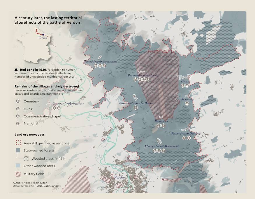
Years ago, in a geography or history class, I learned about an administrative curiosity in France : municipalities who died for their country. In the Verdun region, where the famous battle was fought in 1916, nine villages were completely distroyed by shell explosions. Those villages received military honors, and the government kept them as existing municipalities, with an appointed mayor, even though six of them were never rebuilt and never regained any inhabitants.
I found it to be a very touching way of keeping the memory of what happened : to use geography as a kind of memorial in itself. It quickly made sense to map it out given the extent to which the landscape has been impacted in that region : over a century later, there still is little activity there other than military and forestry.
Tell is about the Tools, data, etc., that you used to make the map
Most of the work was digitizing old military maps drawn during the war to show what the extent of the villages and wood areas were at the time. Luckily the National Institute of Geography and Forest Information inherited a lot of archives at its creation in 1940 and I had access to a library of scanned maps. Then, I read as many articles as possible to find out what kind of ruins if any were still accessible.
I tried to stick to the color palette from the original military maps : the beige of the paper, the blue of the printing ink and the red of the hand written annotations (that’s actually where the « red zone » name comes from, the color of the pencil they used to delimit the zone that was too damage to allow human activity in after the war !)
Leave a Reply