

Born, 1983 Salt Lake City, UT. Resides in Brooklyn, NY. Jennifer Maravillas is a Brooklyn based visual artist. She creates portraits of our land in media ranging from found paper to watercolor. Her aim in this work is to capture universalities and connections across disparate communities by studying social structures from histories, landscapes, and visual design. In 2015, she completed 71 Square Miles: a map of Brooklyn compiled from trash she collected on each block to represent the cultures and voices of the community. She’s continuing her mapping work with her long-term project, 232 Square Miles in which she will walk the remainder of New York City while collecting trash as well as exploring connections throughout historic maps and data. Her background includes studies in anthropology, painting, graphic design, cartography, and mass communication. Jennifer also works as a freelance illustrator creating color-filled works about life and the world. For artwork sales information, please contact the artist through her website. Visit the artist’s website: www.jenmaravillas.com
Jennifer was interviewed by Jonah Adkins
Tell us about yourself
I’m a visual artist currently residing in Brooklyn, NY, though my passion for exploring has led me to live all over the U.S. My art practice is centered around the land and can take many forms- as large painted or collaged maps, landscape paintings, and increasingly in book format. Exploring both the world and artistic media are correlating passions that get me out of bed in the morning.
How’d you get into mapping?
I rekindled my love for maps while working on a personal project in about 2010. It was a now unfinished children’s book about a little girl that learns to fly planes inspired by a good friend. She flies above San Francisco and I decided to color each block as an homage to the psychedelic city. I was hooked. After that I painted a few similar works and realized the physicality of creating a map by hand was an exercise in meditation on that space and history. Flying in planes or staring out of car windows was my favorite thing to do as a kid and this reconnected that love for really appreciating and seeing the land. It’s now become a mode of operating in the world- in my everyday practice as well as travels. These maps have sometimes taken the format of cityscapes while under commission but in my personal work the goal is to connect the medium to the place conceptually.
Over on instagram, i was fortunate enough to see you create your 2018 election map project. How’d it come about?
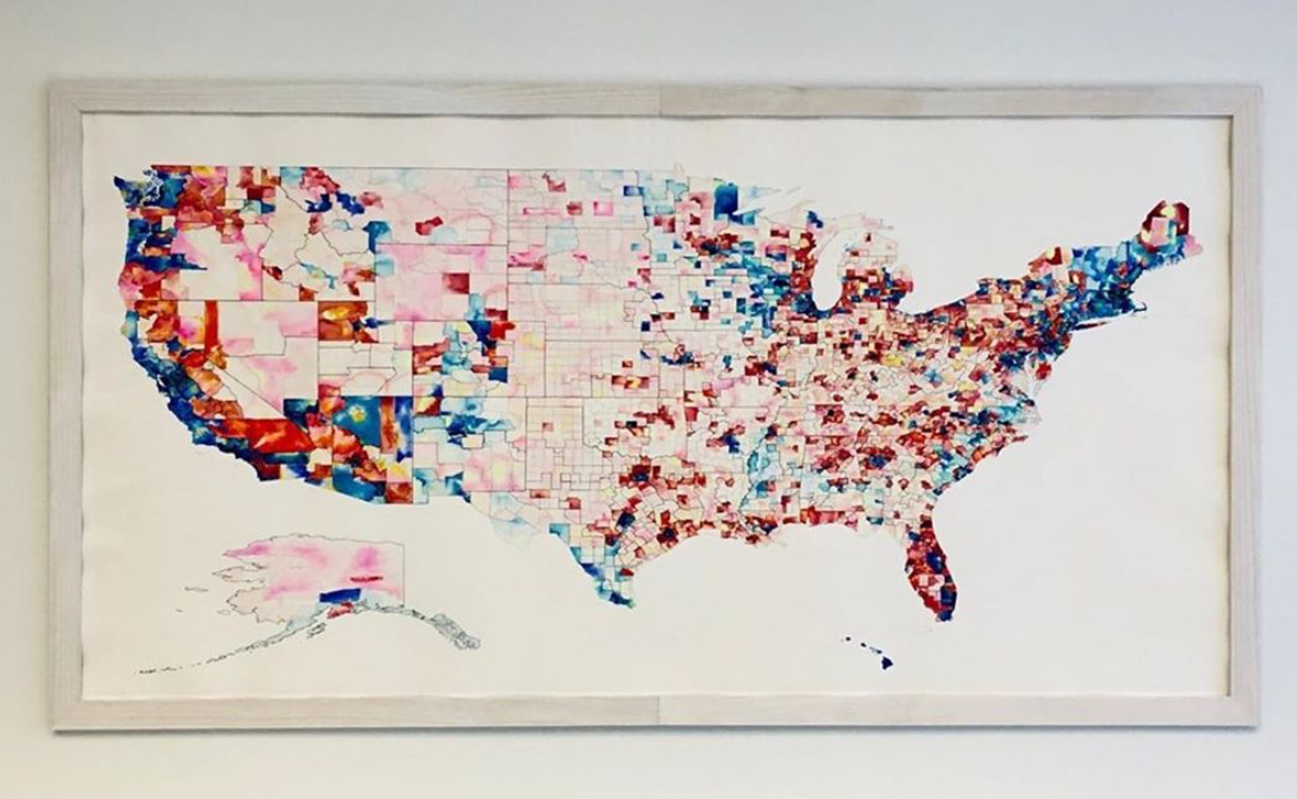
I created a map called Party Line for BallotBox https://www.ballotboxart.com/ – a show curated by Skylar Smith exploring voting rights that was intended to exhibit in Metro Hall of Louisville, KY but now is on view at 21C Louisville. The open call asked artists to explore voting rights to celebrate 2020 as the centennial of the 19th Amendment, the 55th Anniversary of the Voting Rights, and the presidential election.
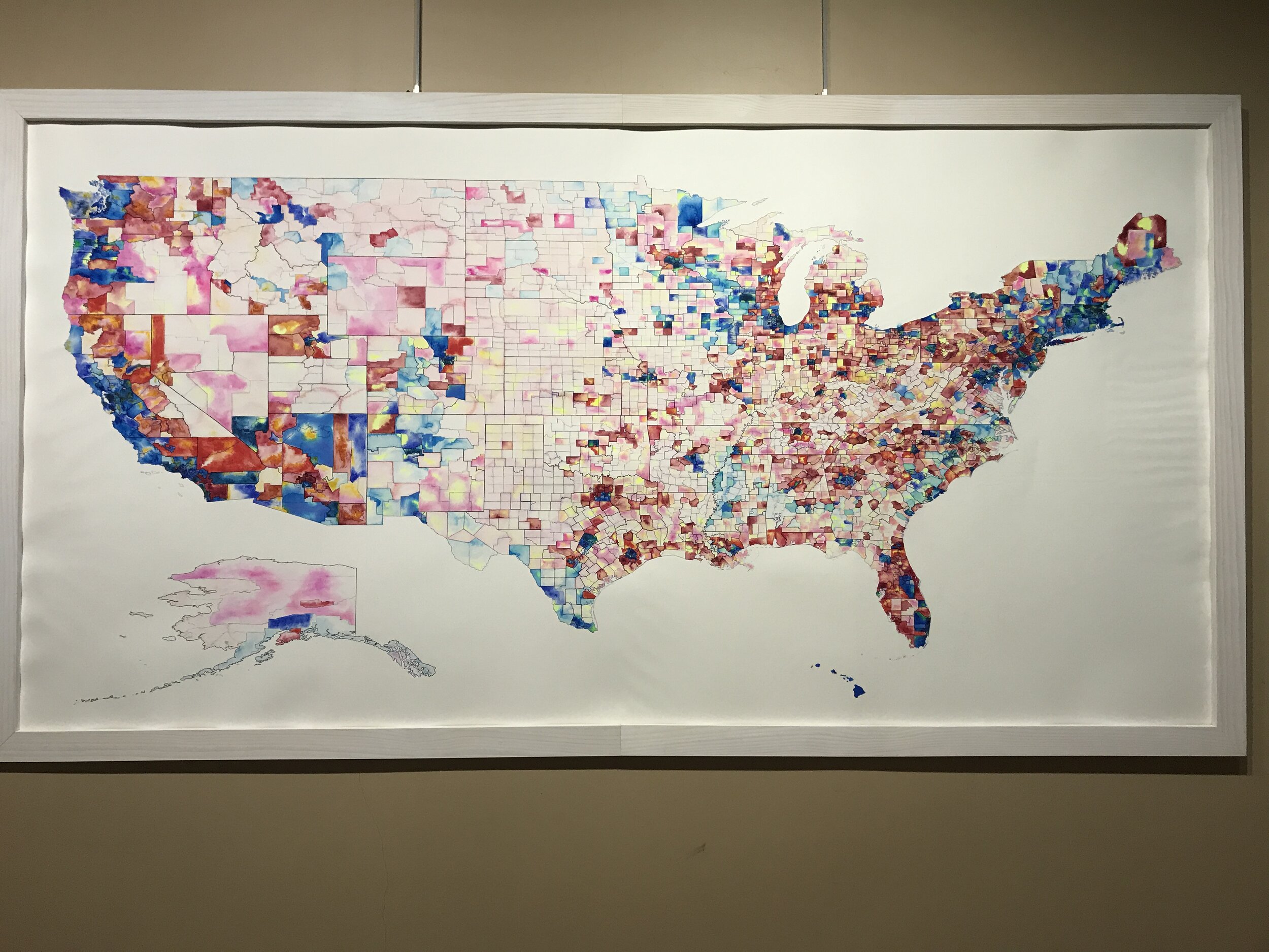


Since this is also a census year I decided to celebrate the right to vote by learning about one aspect of voting which has yet to evolve: the drawing of our congressional district maps. Party Line is a 99” x 55” map of the United States painted in watercolor. Each county is colored in hues of reds, blues, and yellows representing three datasets which show the two methods of gerrymandering- cracking and packing. These colors represent total votes from the 2018 congressional election in each county represented by reds or blues and the system of redistricting by state represented by yellows. Two congressional maps from 2011-2017 are then drawn over the the watercolor in lines.
Here’s my artist statement on the project:
“The United States of America is a country of borders and divisions, though the demarcations between places are often abstract and fluid. This is a concept reinforced by our centuries old tradition of redistricting in which politicians draw lines that represent us as citizen voters. These maps, often drawn behind closed doors, are a work of art to be considered. These lines tell the stories of our country through the imbalance of power and evolution of norms. They represent the redlining of votes and tools of authority wielded in the interests of politicians working toward staying in office, as opposed to representing their constituents. One person, one vote is an ideal we have never attained in the election of congress.”
It was mesmerizing to watch your technique throughout the process. Can you elaborate on your technique and methodology?
This was the first map I’ve ever painted that is quite this rich in data. This process was 100% a learning curve. Viewing the end product as more of a pastiche and compilation of maps instead of an infographic gave me a bit of confidence. My goal was to show county results contrasted with lines of the congressional districts to highlight cracking, packing, and also more generally- the entire country as this network of divisions and connections.
I compiled all of the 2018 election data onto county maps of each state for reference in determining the hue and value for each.


I scaled the US Gov county map in QGIS and then Illustrator, printed it on a large format printer, and traced it all onto a 99” x 55” roll of watercolor paper.


Working across the United States I painted each range of values at a time.

I completed the painting in a very focused three months.
Where can we see it?
The exhibit was set to open March 2020, the opening night was cancelled as the country locked down and was never opened to the public. After the shooting of Breonna Taylor and subsequent marches, Metro Hall has remained closed (it is the seat of the government in Louisville, containing the mayor’s office etc.) Just last month the museum / hotel 21C Louisville generously moved all of the work to their galleries where it will be up until January of 2021.
What other map stuff are you interested in?
It’s been fascinating to learn more about the culture around mapping- from the technical GIS to those collecting, archiving, and sharing historic maps. Ours is such an interesting time when we have better access to historic maps online and we have never understood the earth so clearly. I’m really interested in all maps as archives of vernacular and viewpoints of self and others.
My work is in flux at the moment. My main project for almost the last ten years has been to walk around NYC collecting trash to compile onto large scale block by block maps of each borough. I’ve finished and exhibited 71 Square Miles, a map of Brooklyn. The others are now indefinitely paused because of the pandemic. I will finish those but plan to leave and come back another time when I don’t have to worry about not getting sick quite so much.


I’m not entirely sure what types of mapping I’d like to do next but it will hopefully involve bridging aspects of our communal lives with the land and each other.
The intersection of art and maps can be tough for people trained in mapping, but not design. Tell us about your experience fusing them, coming from a design background?
The physicality of creating maps is what draws me to the work. Finding orientation in a place through movements of my hand gives me a feeling of empathy and wonder at the world. In a larger sense I find a connection between my art practice and maps in the design of my life. Though I was trained as a graphic designer and use those skills regularly, those principles transcend all of our lives down to what we pay attention to, how we spend our time, and how we move through the world. Mapping has given me the focus to see the world and I’ve been privileged to share that vision through colors.
Any inspirations or advice to give our technical mapping audience on interjecting art into their work?
Visualizing a process or the feeling of an end product is typically where my projects begin, though I think the main aspect of realizing any artistic practice is to be aware of what actions most inspire you. My goal is often to think of the craziest / largest / most difficult / most repetitive way to represent an idea which also utilizes a medium representing the concept. Media is where our ideas meet the viewers of our work and it’s difficult but satisfying to find a connection between the reasons for choosing one over another.
Leave a Reply